Saturday, August 22, 2009

Uvas Canyon County Park

Today we did the Bay Area Hiker's site featured hike for Uvas Canyon County Park.   
 
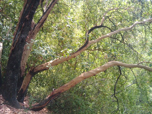
We started off on Alec Canyon trail. This was a steady moderate climb back and forth thru some switchbacks for about 2/3 of a mile. This is a wide trail with plenty of shade, and park bench with a great view for a quick rest.     At the 0.7 mile mark,  we took a sharp right turn onto Contour trail.   Contour trail is a shady single track with a nice layer of leaf litter covering most of the trail.   Contour trail meanders up and down - mostly up but not as steep as Alec Canyon trail.   As mentioned in the BAHiker guide, there is a steep drop to the right side for most of this trail, but there were only a few times where it was uncomfortably narrow.  It might be somewhat more scary if the ground were wet and loose.
 
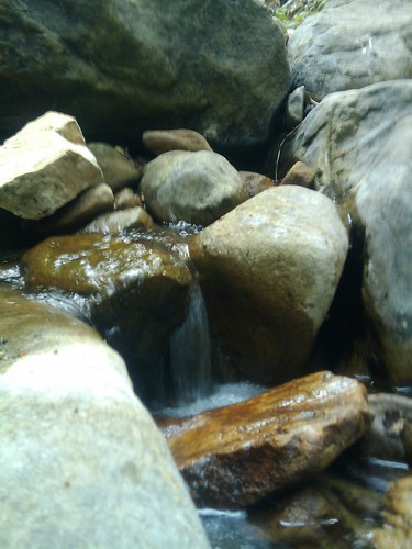
     The first part of the hike was very quiet - We did not run into another group of hikers for almost two miles at the beginning of our hike. It started to get busier as we got to the bend where Contour trail meets Swanson Creek.    As we started following the creek down, shortly after the bend there was a great spot to stop and have a snack; a large flat rock in the middle of the creek, surrounded by small waterfalls.   
 
    Swanson Creek apparently runs all year; in late August without any rainfall in recent memory, the creek was running - not much, but enough to power the many small waterfalls that cascade down this mountain creek.  Once Contour Trail hits the creek, the trail heads mostly downhill for the remainder of the journey.    Through this area there are some fairly steep sections, but the steepest sections have makeshift steps.   The trail widens a bit through this stretch, and comes up on Upper Falls - there is a nice area to watch the falls from the base, or you can play around at the top.    Right near the base of Upper Falls, a short trail heads off to the left up to Basin Falls.  

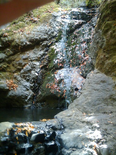
Basin falls was also still running even in this dry season, with a nice pool collecting the trickling falls.    Back to the main trail, and a little further down was another trail leading off to the left which led to Black Rock falls.   This one was not much to look at in dry August.
 
Back to the main road, we chose to take the southern part of Waterfall Loop trail back towards the trailhead.  This trail stays close to the creek and eventually meets back up with the Waterfall Loop Fire Road.   We deviated slightly from the featured hike - there was a branch to the left near where we originally split off on Alec Canyon road, signed as Swanson Creek Trail.   Down this trail were a few more nice falls.   We crossed over a road and headed back down Swanson Creek Trail, which continues to closely follow the creek.  A short walk later, this trail intersects a cutoff trail that heads back up to the parking area which is right up the hill.   Apparently, this trail continues on for a while longer, to where Swanson Creek empties into Uvas Creek, where there is another set of nice waterfalls - we will target that for next time!

Upsides:  Near a running creek even in the summer, beautiful waterfalls, first half of trail very quiet, long but easy drive

Downsides:  Only a few trails, main loop only about 3.2 miles, the water and moisture makes for more bugs, more trail traffic with young kids along waterfall loop

We will definitely return to this park in the wetter seasons to see the waterfalls and creeks going full force!

Sunday, August 16, 2009

Portola State Park

This weekend, we did a hike at Portola State Park.     This park is located down twisty Alpine road, about 15-20 minutes from the intersection of Alpine Road and Skyline.    Alpine is an adventure in and of itself - a narrow twisty mountain road.   There can be lots of bicyclists out on this road on the weekends, so watch out for bikes, especially on the uphill sections.

There is a well staffed ranger station, and we did an approximately 6 mile  loop hike that was recommended to us by the park rangers.   

From the parking lot near the ranger station, we crossed the street and started off on Iverson Trail.   Iverson trail climbs for a short amount of time before intersecting with Coyote Ridge Trail.     Coyote Ridge Trail is a single track trail that starts off with fairly steep climb through some mixed forest and beautiful redwoods.   This trail forks around a mile and a quarter into the hike, with Coyote Ridge Trail continuing to the right, and Upper Coyote Ridge Trail continuing straight.   We went straight on Upper Coyote.   It goes downhill for a while here, but soon heads uphill again in a fairly steep climb.      North of this fork, the trail is narrow, and fairly overgrown with lots of poison oak - be sure to wear long pants and socks on this hike.    I was wearing shorts and paying too much attention to the overgrown trail, and whacked my head on a tree that had fallen over the trail at forehead height!   The trail is mostly shaded, but are a few places where this trail is at the top of the ridge and opens up to offer some fantastic views to the west over the valley.    

This trail starts to flatten out and head downhill a little bit, and goes through some interesting terrain - redwoods, some woods and brush, followed by a more open meadow.    We stopped amongst some redwoods up here for a snack, sitting in the soft layer of pine needles.   Also around this point of the trail, it crosses out of Portola State Park and into Pescadero Creek County Park.    Soon after this open meadow,  Upper Coyote Ridge Trail ends at Tarwater Loop Trail.   We turned left at Tarwater Loop Trail which begins a wide, shady walk downhill.    This trail also crosses some through some nice open meadows before becoming narrower as it heads into a nice grove of redwoods through a soft carpet of needles.     This was my favorite part of the hike, dark and quiet and peaceful.

This trail eventually leaves the redwood groves and intersects Bridge Trail, which is a wide fire trail, where we turned left.    A very short time later we turned left again at Pomponio Trail.     This trail starts uphill and then levels out to some light up and down.    This trail narrows to single track after a while, and goes through some areas where there are fallen trees and other obstacles across the trail.    This trail was also muddy in a spot or two.    We could hear and occasionally see Pescadero Creek to our right as we made our way west, closer to the ranger station and crossed back from Pescadero Creek County park back into the Portola park. 

From this point, the trail takes some interesting twists and turns and heads back uphill a ways.  There are several trail intersections through here, and I am not sure the names of all of the trails we followed, but we tool the clearly marked signs back to the ranger station.    These signs eventually led us back to Iverson Trail and past the intersection where we'd previously turned on to Coyote Ridge Trail.    A short walk downhill on Iverson trail and we were back at the car.

On the way in, we'd noticed that there was a sign for fresh eggs on the west side of the road.    On the way back, we stopped in to a nice farmhouse with some wonderful folks selling the eggs of their flock of chickens.    We bought a dozen farm fresh eggs for $2.50 and had a nice conversation with the owners of the property -- this is a great place to stop on the way in if you are camping at Portola or on the way out after a day of hiking!

Upsides:   Lots of different trails of various difficulty,  very diverse terrain from open meadows to deep redwood groves, very few other hikers on these trails so lots of peace and quiet, fresh eggs, huge park system to explore (Portola + Pescadero Creek + Sam MacDonald parks all adjacent)

Downsides:  Some trails overgrown with poison oak

Notes for next time:  Try out Pomponio trail to see the waterfalls along Pescadero Creek

Google MyTracks Trail

Sunday, September 03, 2006

California Coast

Becky and I took off for an overnight trip last weekend for our anniversary/my birthday. We had a great time driving down highway 1, always a beautiful drive.

We stayed overnight at Lucia Lodge. Lucia is a tiny town along the coast of highway 1 - the permanant population of this town is somewhere between 20 and 30 people. There are 10 cabins there, which I guess almost doubles their population on a busy night. We've stayed here once before when my mom and dad were in town, the people are great. Food and supplies down in that area are kind of expensive, but where else are you gonna eat - the next big towns are hours away in either direction. There's a great restaurant down in Gorda Springs, the town south of Lucia, about 15 minutes away, called Whale Watchers Cove. The food there is expensive but tasty, and the baked goods are amazing. (mmmm, pies!)

Monday, May 01, 2006

San Jose Immigration Rally

Today was in downtown San Jose and saw the immigration rally. We saw some police action from the 14th floor of 55 Market -- closing the streets and stuff. A few hundred people walked by. I thought "Oh, that was neat". Ben and I played a game of air hockey, walked back to the office, and when I came back, the street was packed, shoulder to shoulder, with people in white shirts as far as I could see. I grabbed my camera and went down to the street, it was amazing seeing the turnout, and the enthusiasm. The papers said there were over 50,000 people in attendance.

Saturday, April 08, 2006

Jacob's First Birthday

I am finally getting around to posting some of my pics and stuff online. Here is a photoset from Jacob's first birthday.